Perfect bodies of water for paddling
The paddle and kayak community will tell you that Salaberry-de-Valleyfield is THE destination near Montreal! No fewer than six sites offer launch points and sometimes even rentals. Whether you choose the bay, lake, river, or the river, the experience will delight you.
Finally, head to downtown: it’s just as food-oriented as it is nautical. Don’t miss sipping on a cocktail or a local beer at one of the many terraces and discovering the distinctive menus of our independent restaurateurs.
Target people

1. Baie Saint-François
Just for the fun of it
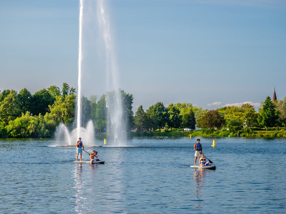
Downtown Salaberry-de-Valleyfield hugs the shore of Baie Saint-François. Paddle between Delpha-Sauvé Park and Pointe-aux-Anglais. Catch a refreshing spray from the giant fountain along the way. Follow the shoreline and the park past the marina to Parc Marcil at the entrance to Lac Saint-François. The return journey is easier as you will have the current with you. On the way back, take a short detour via the Old Canal, a sheltered area between the boardwalk and the park. Pass under the swing bridge and soak up the lively terrace atmosphere before returning, unless you decide to dock there.
Useful info
— Address and parking: Delpha-Sauvé Park. Access via Nicholson pier or Parc Marcil. Free parking.
— Launch point: The dock in front of the rental kiosk, to the left of Flotel (you can sleep there and launch from the deck of your unit), within walking distance of the parking lot.
— Services: Baie Saint-François rentals, Récréation Marine rentals, restrooms, restaurants, terraces, specialty grocery stores , and stores within walking distance.
— Activities: Swimming, scuba diving, cycling, etc. Keep an eye on the events calendar!
—Type of course: Loop, but you can always stop at Parc Marcil and walk back to your car.
— Safety:
- Boat traffic in the bay can sometimes be quite heavy, so be vigilant.
- Enter the canal only when the bridges are closed, that is, when not in operation for boats, and navigate on the side of the street/boardwalk.
- If you must pass through the entrance channel between the lake and the bay, make sure you’re seen by the boats, and don’t linger there.
— And lastly:
- This is the site of the Valleyfield Regattas, so kayaking and paddleboarding are not permitted during the races.
- The wind and current coming in from the lake make paddling harder than you might imagine.
- The water is deliciously refreshing!
- The view and sunset are spectacular!

Rivière Saint-Charles
For the joy of exploring
The Rivière Saint-Charles originates in Baie Saint-François and winds discreetly through the city. An unexpected bucolic haven in an urban setting, this is a great place for a leisurely float while offering a few little rapids here and there along the way.
1) Riverside Park Dock
Parking: Behind the Centre d'éducation aux adultes Nouvel Envol. Street parking available, as well as a drop-off area.
Route Type: One-way only – plan for a shuttle vehicle at your exit point.
Possible exits: Sullivan Park, Dufferin Lookout/Parent Street, Notre-Dame-du-Sourire (Masson Bridge), Îles-de-Saint-Timothée Regional Park (note: rapids under Masson Bridge – not recommended for inexperienced paddlers). Important: There are rapids and construction work on/under the Highway 132 viaduct. Instructions: Exit at Parc Masson/Notre-Dame-Du-Sourire, portage by crossing the road, and get back on the water after the viaduct.
A map on site shows the recommended crossing spot for your portage adventure!
2) Dufferin Lookout / Parent Street
Parking: Limited spots directly along the river, or nearby street parking.
Route Type: One-way only – plan for a shuttle vehicle at your exit point.
Possible exits: Notre-Dame-du-Sourire / Masson Bridge or Îles-de-Saint-Timothée Regional Park (note: rapids under Masson Bridge – not recommended for inexperienced paddlers). Important: There are rapids and construction work on/under the Highway 132 viaduct. Instructions: Exit at Parc Masson/Notre-Dame-Du-Sourire, portage by crossing the road, and get back on the water after the viaduct.
3) Masson Bridge / Notre-Dame-du-Sourire
Parking: Limited spots along the river, or nearby street parking. Follow posted signage.
Route Type:
• Option 1: Loop route possible within this section of the river.
• Option 2: One-way to Îles-de-Saint-Timothée Regional Park (note: rapids under Masson Bridge – not recommended for inexperienced paddlers). Plan for a vehicle at your exit point. Important: There are rapids and construction work on/under the Highway 132 viaduct. Instructions: Exit at Parc Masson/Notre-Dame-Du-Sourire, portage by crossing the road, and get back on the water after the viaduct.
SAFETY NOTICE:
⚠️ Important: There are rapids and construction work on/under the Highway 132 viaduct. Instructions: Exit at Parc Masson/Notre-Dame-Du-Sourire, portage by crossing the road, and get back on the water after the viaduct.
Tips for a safe outing:
- Preview your route: Use Google Maps (satellite view) to locate landmarks and plan ahead.
- Follow posted signage: Work on Masson Bridge is planned for summer 2025. Safety nets and on-site instructions will indicate where to exit or portage.
- Water levels vary: Be cautious of underwater rocks, especially before entering the rapids. Consider temporarily removing your fin to avoid damage. Watch out for slippery rocks!
- IMPORTANT: Do not paddle past the entrance to Îles-de-Saint-Timothée Regional Park due to downstream dams.

Parc des îles de Saint-Timothée
For some adventure
Launch from the beautiful sandy beach of the Îles-de-Saint-Timothée regional park and explore its two islands located in the crystal-clear waters of the Saint-Timothée basin. A truly enchanting site!
Useful info
— Address and parking: Îles-de-Saint-Timothée regional park, 240 Saint-Laurent Street, Salaberry-de-Valleyfield. Admission fees apply, except for residents (upon presentation of the Accès loisirs card).
— Launch point:
- Got your own gear? Use the boat ramp at the end of the parking lot.
- Need to rent equipment? Go to the watercraft rental kiosk.
— Services:
- Canoe, kayak, pedal boat and paddleboard, bocce ball, and spike-ball game rentals.
- Snacks and ice cream sold on site.
- Picnic tables, volleyball courts, hiking trails, play modules, restrooms.
- Padlocks available for rent at the rental kiosk.
—Type of course: Loop.
— Attention:
- It is forbidden to enter the swimming areas with a watercraft.
- DO NOT APPROACH THE DAMS as the current can be very strong. Test the water before you go too far, and don’t hesitate to ask the team on the site for advice.
- Use the designated paddleboard rack.
— And lastly:
- The park is an exceptional birdwatching site. Keep an eye out for small wildlife around you.
- You’ll definitely want to sink your teeth into Valleyfield’s famous “sandwich aux grillades” and sip on some refreshing mocktails.
- Look for the Saint-Timothée church steeple facing the one in Les Cèdres.

Vieux-Canal Est
The easiest
Today, the canal—the first Beauharnois Canal, which was built through the town of Salaberry-de-Valleyfield—is divided in two sections. The western part, dedicated to boats and open to the lake, has a festive atmosphere, while the renaturalized eastern portion offers peace and tranquility, even if it’s just a stone’s throw from the heart of downtown. It’s not accessible to boats and therefore perfect for first-time paddleboarders or paddleboard yogis.
Useful info
— Address and parking: Free parking at the public market (51 Hébert Street) or the public parking lot between Hébert and Victoria streets.
— Launch point: The stone steps leading down to the canal, facing the public market on Hébert Street, a few steps from the parking lot.
— Services: Downtown shops, restaurants, and specialty grocery stores within walking distance.
— Activities: Treat yourself to a soft-serve ice cream just across the street at La Lèche-crème, soak up the sun on one of the deckchairs along the canal, enjoy a workout on the Trekfit equipment, or go swimming, scuba diving, or cycling. You’re just a few minutes’ walk from Parc Delpha-Sauvé. Keep an eye on the events calendar!
— Type of course: Linear, out-and-back
— And lastly:
- Very calm water. Perfect for beginners or on windy days.
- Ssshh... Can you spot the small wildlife hiding all around you?
- Admire the Jean-De La Lande bridge, its history engraved in stone, its lighting... and the padlocks attached there as symbols of everlasting love!
- Marvel at the vegetation of this site, which has been renaturalized to regenerate biodiversity.

Parc Marcil
Just past the marina, Parc Marcil provides access to Lac Saint-François, an important gateway into Quebec from Ontario and the U.S. along the St. Lawrence River and Great Lakes maritime corridor. The 50 km-long lake is known for the remarkable clarity of its waters.
Useful info
— Address and parking: Parc Marcil. Free admission. This park is slated to undergo a complete makeover and will eventually be redeveloped into a destination park.
— Launch points: Use the natural spots accessible from the shore.
— Services: Picnic tables.
— Activities: Swimming, scuba diving, cycling. You’re just a few minutes’ walk from Parc Delpha-Sauvé and downtown, where you can explore shops, restaurants, and specialty grocery stores. Keep an eye on the events calendar!
— Type of course: Linear, out-and-back. You are advised to travel along the south shore of the lake to avoid crossing the entrance channel to Baie Saint-François.
— Safety:
- Watch out for motorboats.
If you need to cross the entrance channel (the buoy-marked path used by boats entering the bay), make sure you're visible to boaters and don't linger. We do not recommend crossing the channel — it's safer to follow the shoreline.
- When heading out to the lake, you’ll be travelling against the current and the wind. The return journey will therefore be easier but beware of distances: an island that appears close is further away than you might imagine!
- Bring water and snacks.
Fleuve Saint-Laurent - Quiet zone
For a tranquil float
The St. Lawrence River flows around Salaberry-de-Valleyfield to the north. This stretch is calm, and the water level can be low in places because this area is relatively isolated between the rapids and dams. The greatest volume of water flows south of the city, via the seaway.
Useful info
— Address and parking: Parc Bord-de-l’eau. Free, but please respect the signs.
— Launch points: Small boat ramp and dock on site.
— Services: Picnic tables, chemical toilet.
— Activities: Close to downtown.
— Type of course: Linear, out-and-back.
— Safety:
- Caution: this section is quite isolated, so don’t head out alone.
- The current flows from west to east, so start by heading upstream towards the Coteau-du-Lac National Historic Site fort on the north shore or Camp Bosco on the south shore and let yourself be carried back.
— And lastly:
- A very peaceful spot. A large bird population and a veritable heron reserve!
- Make a pitstop on one of the outcrops to soak up some sun and have a snack.